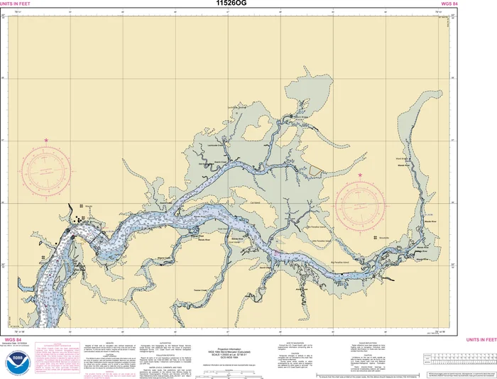
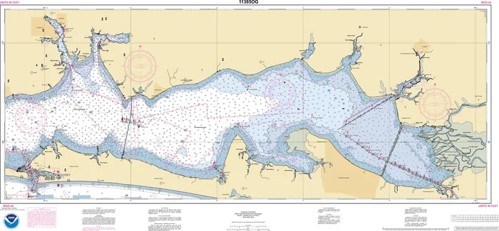
Description
As of December 31, 2024, NOAA has retired traditional paper nautical charts by chart number. While these charts are no longer updated, NOAA continues to maintain and publish all underlying hydrographic data.
In partnership with NOAA, OceanGrafix offers Print-on-Demand (POD) charts that use the latest official NOAA data. Updated weekly, these charts retain the same chart number and are marked with an “OG” suffix, indicating they reflect the most current information available. The OceanGrafix OG charts are printed fresh on premises per order just like we have done for over 10 years and counting.
Each chart features enhanced detail, improved color contrast, and is available on standard or waterproof paper—backed by NOAA’s authoritative data.
For weekly NOAA chart updates, please click here
Click here to access the Zone of Confidence (ZOC) diagram along with important notes. You can either view the information or print it. This chart may or may not contain insets.
Full chart catalogs by region.
- NOAA Atlantic Charts Catalog Reference (.pdf)
- NOAA Gulf Charts Catalog Reference (.pdf)
- NOAA Pacific Charts Catalog Reference (.pdf)
- NOAA Great Lakes Charts Catalog Reference (.pdf)
- NOAA Alaska Charts Catalog Reference (.pdf)
These charts can be ordered three ways:
- [-WR] Water Resistant paper is our Standard format. Measuring from 36-40″ to 40-44″.
- [-WP] Waterproof paper: printed on a fully waterproof synthetic material for longer life, stain resistance and durability. Measuring from 36-40″ to 40-45″.***if your planning on framing – please select the Waterproof paper version. The colors are much brighter.
- [-TR] Tri-fold paper: comes as a convenient 7″ x 12″ tri-fold. Length varies by chart number. Tri-fold is only available on water resistant [-WR] chart paper.
As of December 31, 2024, NOAA has retired traditional paper nautical charts by chart number. While these charts are no longer updated, NOAA continues to maintain and publish all underlying hydrographic data.
In partnership with NOAA, OceanGrafix offers Print-on-Demand (POD) charts that use the latest official NOAA data. Updated weekly, these charts retain the same chart number and are marked with an “OG” suffix, indicating they reflect the most current information available. The OceanGrafix OG charts are printed fresh on premises per order just like we have done for over 10 years and counting.
Each chart features enhanced detail, improved color contrast, and is available on standard or waterproof paper—backed by NOAA’s authoritative data.
For weekly NOAA chart updates, please click here
Click here to access the Zone of Confidence (ZOC) diagram along with important notes. You can either view the information or print it. This chart may or may not contain insets.
Full chart catalogs by region.
- NOAA Atlantic Charts Catalog Reference (.pdf)
- NOAA Gulf Charts Catalog Reference (.pdf)
- NOAA Pacific Charts Catalog Reference (.pdf)
- NOAA Great Lakes Charts Catalog Reference (.pdf)
- NOAA Alaska Charts Catalog Reference (.pdf)

Reviews
There are no reviews yet.