Description
OceanGrafix and Landfall Navigation have joined forces to provide you with the most up-to-date nautical charts. Your charts are printed to order, and updated to last week’s Notice to Mariners corrections. The standard charts are water-resistant with a tough coating for longer life. Bright colors make them easier to read under varying light conditions. However, these charts can be ordered three ways:
[-WR] Water Resistant paper is our Standard format. Measuring from 36-40″ to 40-44″.
[-WP] Waterproof paper: printed on a fully waterproof synthetic material for longer life, stain resistance and durability. Measuring from 36-40″ to 40-44″. ***if your planning on framing – please select the Waterproof paper version. The colors are much brighter.
[-TR] Tri-fold paper: comes as a convenient 7″ x 12″ tri-fold. Length varies by chart number. Tri-fold is only available on water resistant [-WR] chart paper.
National Geospatial-Intelligence Agency (NGA) Chart Catalogs
NGA Region 2 Central, South America (.pdf)
NGA Region 3 UK, Western Europe (.pdf)
NGA Region 4 Scandinavia, Northern Russia (.pdf)
NGA Region 5 Western Africa, Mediterranean, Black Sea (.pdf)
NGA Region 6 Eastern Africa, Southern & Western Asia (.pdf)
NGA Region 7 South East Asia, Indonesia, New Guinea, Australia (.pdf)
NGA Region 8 Pacific Islands (.pdf)
NGA Region 9 Eastern Asia, South Eastern Russia, Philippines (.pdf)
NGA Region 10 Miscellaneous International (.pdf)
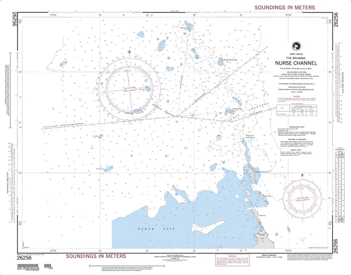
Scale: 1:18,000
Size: 36″ x 24″
Edition Number: 8
Edition Date: 04/01/1995

Reviews
There are no reviews yet.